Mar. 21st, 2005
Does anyone know Cornwall
Mar. 21st, 2005 10:55 pmHow crazy would it be, over one of the May bank holidays, to walk around the end of Cornwall from Penzance to St Ives?
It looks about 60km, so doing it over two days breaking at Lands End YHA should be possible, unless the terrain is hopelessly rough. I'm imagining it'll be like the cliffs at Whitby, so a fair amount of up and down where rivers come in, but not difficult underfoot. If anyone's been there and knows that I'll need disabusing and that consecutive 30km days over such territory would tire Hercules, or that May in Cornwall is noted for its cataclysmic downpours / plagues of carnivorous ladybirds, please tell me before I generate a Nicoll Moment.
The other obvious trip from Penzance is to the Scilly Isles; there are probably people who've tried both means of transport here, is going by helicopter likely to be enough more fun than going by tiny propeller plane to be worth paying £150 rather than £90 for the return trip?
In fact, is anyone reading this also mad enough to want to spend a perfectly good bank holiday in tiring walks, with me, around large, attractive lumps of granite surrounded by cold, attractive seas, at the region the Phoenicians probably thought to be the thankfully staniferous far end of the Earth?
The bones of the earth; a new perspective
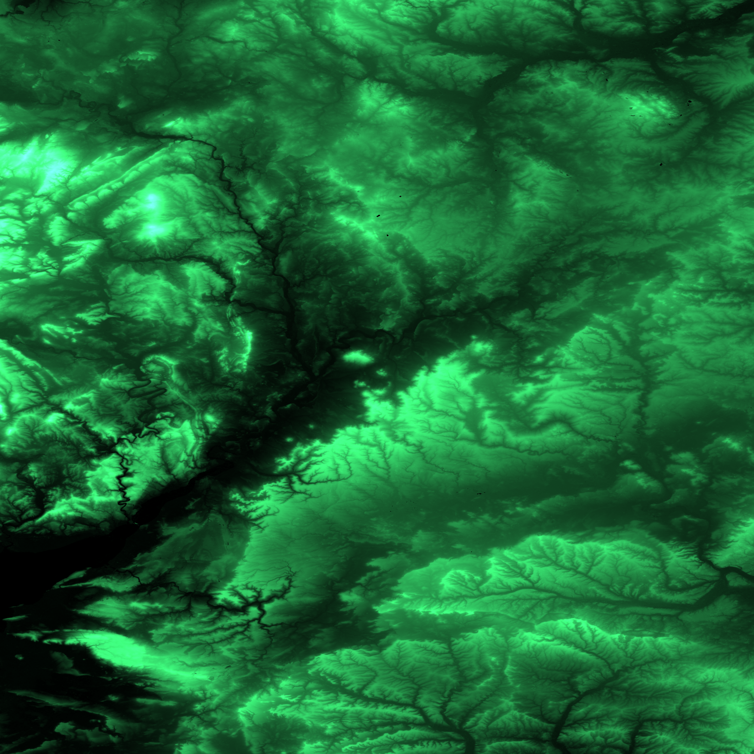
Mar. 21st, 2005 11:22 pmThe Shuttle Radar Topography Mission is one of the esoteric topics I'm most prone to enthuse about; I think of it as the last major donation made by the military-industrial complex to the sum of human knowledge before 9/11, and so possibly the last for some time. Using a fortnight of time on the Space Shuttle, Earth was mapped to 90-metre resolution in position and about one-metre in height.
This is a very interesting resolution; water erosion is the main visible feature, you can see some of the moderate-scale processes of geology (are the long linear features dykes?), and you can't see humanity at all.
ESDI is the best interface to the data I've found so far, though it dispenses data in TIFF-format files, one square degree per file and one 32-bit float per pixel; these aren't viewable in standard software.
If you pull out hexdump, gcc, python and gimp in some order, however, you can get something like

I'll be very impressed if anyone knows the shape of my country well enough to be sure of where that is.
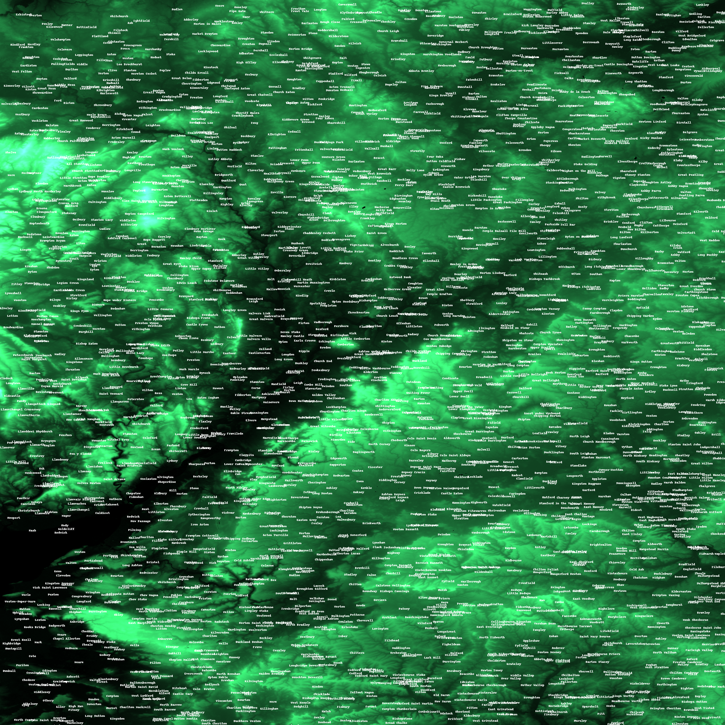
I've got a full-scale version (5MB .PNG) or a version with labels (5.5MB .PNG); I'd recommend downloading these to anyone with the connectivity. The labels come, I think, from a full dump of the National Geospatial Intelligence Agency's GNIS database; coordinates there are rounded to the arc-minute, which is about a mile, so I've positioned them randomly within a two-arc-minute square aroud the given position. This may mean North Wallop is positioned south of South Wallop; sorry.
If anyone's aware of a better freely-available gazetteer, please tell me.
This is a very interesting resolution; water erosion is the main visible feature, you can see some of the moderate-scale processes of geology (are the long linear features dykes?), and you can't see humanity at all.
ESDI is the best interface to the data I've found so far, though it dispenses data in TIFF-format files, one square degree per file and one 32-bit float per pixel; these aren't viewable in standard software.
If you pull out hexdump, gcc, python and gimp in some order, however, you can get something like
I'll be very impressed if anyone knows the shape of my country well enough to be sure of where that is.
I've got a full-scale version (5MB .PNG) or a version with labels (5.5MB .PNG); I'd recommend downloading these to anyone with the connectivity. The labels come, I think, from a full dump of the National Geospatial Intelligence Agency's GNIS database; coordinates there are rounded to the arc-minute, which is about a mile, so I've positioned them randomly within a two-arc-minute square aroud the given position. This may mean North Wallop is positioned south of South Wallop; sorry.
If anyone's aware of a better freely-available gazetteer, please tell me.