
You will observe that getting a Mac has neither endowed me with a steadier mouse hand, nor greater graphic design skills. Do not tempt me with Wacom tablets of inordinate cost.
![[livejournal.com profile]](https://www.dreamwidth.org/img/external/lj-userinfo.gif) mobbsy
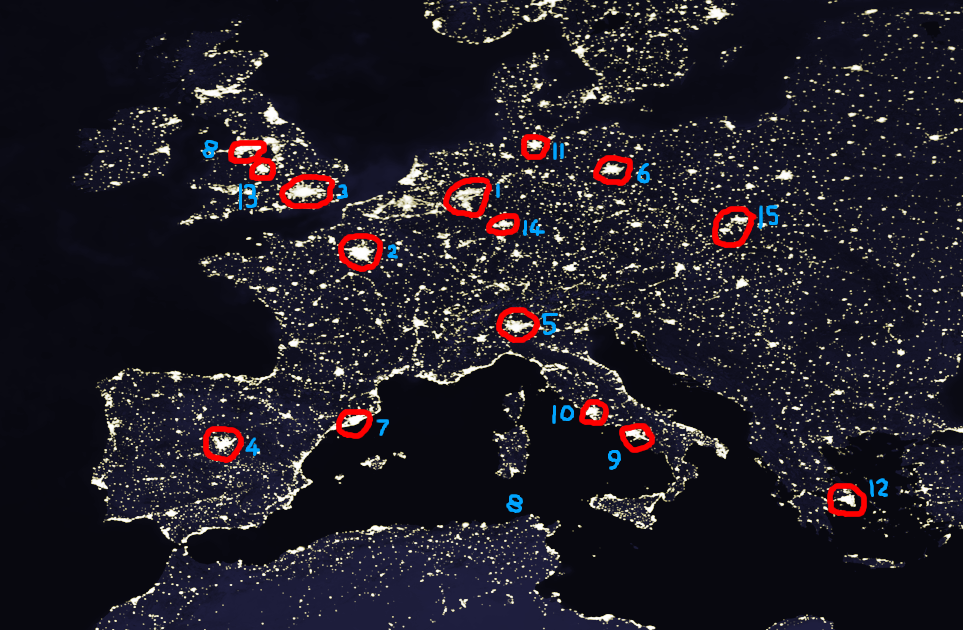
mobbsy: looking at this map of city lights, the Pennines are much more an obstacle to the growth of the Liverpool conglomeration towards the Nottingham-Sheffield and Birmingham conglomerations than anything much in the Frankfurt region manages.
meirion: I don't have any very useful citation information for the database I'm using, but I suspect Manchester is counted as tiny (400k) because the city itself insisted on not being counted as part of the Mersey-and-parts-east blob; Liverpool (city) is marked as 450k, Liverpool (area) as 3.6 million
no subject
The figure I have for London counts suburbs, I think; I have 'london-city' as 7.4M, 'london-urbanarea' as 11.2M. Paris-city is 2.1M, Paris-urbanarea 11.3M.
It might be possible to get better figures by looking for census data broken down by local-government divisions; at really tiny subdivisions, governments consider that more a revenue source, but it may be available at more reasonable aggregations. Is there an obvious French administrative subdivision smaller than a département?
Possibly election maps are the place to look; electoral districts are generally of roughly equal population, so if you colour them with a brightness proportional to 1/area you'll end up with a population-density map.
no subject
Yes, the commune.